Shaking things up
Realising this huge disparity led Jackson and his colleagues, Professor Keith Priestley and Dr Alex Copley in the University’s Department of Earth Sciences, to ask how they could use science to increase developing countries’ resilience to earthquake risk.
Together with Professor Philip England at the University of Oxford, the team had developed a long-term relationship with collaborators across the Mediterranean–Himalayan–Asian earthquake belt, many of whom advise their respective governments on earthquake hazard and risk. In 2012 they leveraged this relationship to establish ‘Earthquakes without Frontiers’ (EwF), a consortium jointly funded by the Natural Environment Research Council and the Economic and Social Research Council, to support physical and social scientists working to increase resilience to earthquakes in Asian countries.


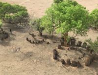
Tien Shan mountains of central Asia. An EwF collaborator from Kyrgyzstan (centre) shows Nepalese collaborators the fault that moved in the 1911 earthquake, destroying Almaty in neighbouring Kazakhstan.
Tien Shan mountains of central Asia. An EwF collaborator from Kyrgyzstan (centre) shows Nepalese collaborators the fault that moved in the 1911 earthquake, destroying Almaty in neighbouring Kazakhstan.
Cambridge research has shown that seismic risk is higher in continental interiors, where the network of geological faults is much less well defined, than at plate boundaries. Devastating earthquakes such as those in Bam, Iran (2003; 30,000 deaths), and Muzzafarabad, Pakistan (2005; 75,000 deaths), invariably take place on faults that were either previously unknown, or whose threat had not been recognised, making hazard assessment and development planning impossible.
At its heart, EwF uses science to help developing countries be better prepared for earthquakes. In Tehran, for example, work by EwF identified a new fault line, subsequently named the Pardisan fault. This was a major step in evaluating the earthquake hazard to this city of over 10 million people.
In another of its focus regions in north-west India, EwF identified an area at the entrance to the Kashmir valley at risk of a major earthquake at some point in the future. The likely effects of that earthquake will be to block all the roads and completely cut off the Kashmir valley.
“We can’t say when it will happen, but when it inevitably does we can estimate how big it will be, where the shaking will be and how long it will last”
says Jackson, adding: “Long-term forecasting is a matter of understanding the local geology, what happened before, and how earthquakes work in that part of the world. Then there’s a lot you can do to prepare.”

A Nepalese EwF collaborator (centre) shows collaborators from India (left) and Iran (right) some particularly vulnerable buildings in central Kathmandu, Nepal - which were later destroyed in an earthquake in 2015.
A Nepalese EwF collaborator (centre) shows collaborators from India (left) and Iran (right) some particularly vulnerable buildings in central Kathmandu, Nepal - which were later destroyed in an earthquake in 2015.
Earthquakes in major cities today have a much bigger impact than in the past, in part because of their much bigger populations. In a two-year scientific study, EwF’s Nepalese partners forecasted the impacts of an earthquake in Kathmandu on public ‘lifelines’ including water supply, electricity, and phone networks, and created a picture book for the public showing the unfolding scenario day-by-day.
“Two years later the earthquake actually happened – and jeepers, you could just turn over the pages of the book and it was all accurate!” says Jackson. “That had a huge impact on the Chinese, who wanted us to do the same thing there.”
“Earthquakes without Frontiers was an experiment no-one had tried before”
says Jackson, adding: “We had the previous experience of working with people in all these different countries, and we wanted to see what happened if we tried to connect them all.”
What happened was that scientists in developing countries no longer felt that they were working alone. “In India, for example, we did a mixture of collaborative science, learning about the region to assess earthquake hazard and risk, and bringing in contacts from other developing countries in the EwF network to talk to Indian officials about contingency planning,” says Jackson. “That really helped the Indian scientists to be taken seriously and to influence those responsible for public safety.”